The Summits of Fire Trek

The Summits of Fire Trek
Hardcore Hardcore
6000m +
13 Days
£3,295pp

Trip Overview

Mobile Trip App

Mobile Trip App

Take preparation to the next level with free access to our Mobile Trip App. Get maps of your trek, trip countdown timers, our favourite hang-out spots and heaps more. 


Ultimate Trip Flexibility

Ultimate Trip Flexibility

Moving a trip date should be easy right? Hassle-free flexibility. Move your dates, change your trek or your payments for free at any time as well as be covered under our Ultimate flexibility promise.

13 days of adventure along the Summits of Fire Trek in Ecuador, which includes reaching the summits of 4 of Ecuador's highest volcanoes, Imbabura (4560m), Cayambe (5790m) Cotopaxi (5897m) and finally the mighty Chimborazo (6268m). This is a true South American adventure offering you a full immersion into the sights and sounds of Ecuador as well as experiencing some serious altitude in one of the world's most beautiful mountain ranges.

The EverTrek Summits of Fire Trek in Ecuador is truly erupting with adventure! Starting in the city of Quito you will already get a taste of what lies ahead as on a clear day you can see the snow capped peaks of the volcanoes that surround the region and that's where you are heading, right into the epic 'Ring of Fire'. 

The Surrounding Andres offers gorgeous nature, exotic indigenous villages where you can mix with the locals and experience their way of life and learn about their cultures, all while starting to acclimatise for summits ahead. On your way to the 6268m summit of Chimborazo you will trek around the Cuicocha lake, practice climbing with your crampons, ice axe and ropes on the Cayambe glacier and reach the summits of 3 more of the region's highest volcanic peaks. A great trekking and climbing route, offering great access to accommodation facilities with the right balance of remote adventure and support to make your trip a success.


IMPORTANT INFORMATION - Update as of 02/02/2023


Please click here for an alternative itinerary which all Summit of Fire trips will follow until further notice.


With Cotopaxi, one of the Volcanoes we summit on our usual Summits of Fire trek, suddenly becoming active in the later months of 2022, we have created an alternative itinerary to ensure that our awesome adventures can still proceed. This alternative route will miss Cotopaxi and will instead include the summit of the equally awesome - North Iliniza (5126 m). Part of the itinerary follows our usual path, with the changes impacting Days 3 to 10. Please follow the above link to view the full itinerary which we expect our Summits of Fire treks to follow in 2023 (and possibly beyond), whilst Cotopaxi remains inaccessible for all trekkers.


When Cotopaxi eventually settles and the summit is deemed safe for trekkers, we will contact all customers with the happy announcement - from this point our normal itinerary should resume.


Please Note

This trip requires a minimum number of 2 EverTrekkers to guarantee it goes ahead. We will notify you at the time full payment is due (6 months prior to trip start date) if the trip going ahead or if the minimum number of bookings has not been achieved.

We therefore recommend you do not incur any non refundable expenditure until you have received confirmation that your trip is guaranteed to proceed.
We recommend you read our minimum number T&Cs (Section 6c) before booking: https://evertrek.co.uk/about-us/terms-conditions


Join us on the Summits of Fire Trek

  • A unique and challenging trip that offers the chance to climb 4 of Ecuador's volcanic peaks.
  • Climb a Chimborazo Peak reaching an altitude of over 6000m with spine-tingling views. 
  • Our Team in Ecuador have been guiding summits of these volcanoes for over 10 years and are some of the most experienced in the region offering you the best chance of success.
  • We take special care of our porters & guides. They are probably the best equipped in Ecuador.
  • Your kit bag is carried for you, so you only need carry a day pack.
  • Prices include all climbing permits permits.

Experience Required

The 13 day Cotopaxi & Chimborazo Summits of Fire itinerary is a tough and arduous trek and climb. It is meant to be challenging. You must be a fit, regular hillwalker to take part, used to long, consecutive days walking in the British Mountains, preferably in Winter conditions. You should have experience walking steep, boulder-strewn paths where the use of hands has been essential to scramble upwards over rocky steps. Previous experience of altitude would be an advantage as you will be reaching over 6000 meters. 

Equipment 

We've put together this equipment list for our trekking peak trips like this one, Mera Peak, Island Peak and others. Although this list is quite detailed there might be some bits you might also want to bring that form part of your expedition or trekking kit.


What's Included?
  • Airport Pick-up and Drop-off
  • All accommodation for the 13 day itinerary
  • Full-day guided city tour
  • All overland transfers
  • All Trekking and climbing permits for each mountain/Volcanoe
  • All meals (breakfast, lunch and dinner) during the trek
  • All accommodation whilst on trek (Hut/mountain refuge)
  • Filtered water on the entire trek (Save on plastic bottles)
  • Experienced climbing and trekking guides and all support staff 
  • EverTrek Trip Planner & Mobile App Access
  • Exclusive discounts from Cotswold Outdoor, Osprey, Snow and Rock and heaps more
What's Not Included?
  • International flight to Ecuador
  • Ecuador travel visa
  • Meals in the city except for breakfast and other mentioned special meals
  • Personal expenses including soft drinks, alcoholic drinks, and beverages
  • Climbing gear (Ice axe, helmet, harness, crampons and crampon compatible boots) You can hire these locally on arrival)
  • Your travel insurance that covers Helicopter Evacuation
  • Any other extended trips and accommodation
  • Tips for guides and support staff

Itinerary

Hola! Welcome to Ecuador!

Today is the first day of your South American adventure and a member of the EverTrek team will be there to greet you and welcome you to Quito. Private transfer straight to the hotel for you to relax and get over the long haul flight and enjoy some free time getting to know your fellow EverTrekkers and the local food and drinks.

After breakfast your private tour around Quito begins, you will leave the modern part of Quito and head to the ancient historical part of the city where you will spend time basking in the local atmosphere. Some highlights include the La Basilica Church, La Compania Church and El Panecillo Hill. After some lunch at a local restaurant you will visit Mitad del Mundo where you can stand on the equatorial line and take part in some fun experiments!

Pick-up from the hotel in the morning and then you will drive for around 3 hours to Cuicocha’s volcanic lake, on the way stopping at the Equatorial line and the town of Otavalo. Once you arrive at the Cuicocha park entrance the first day of trekking begins! Hiking around the crater rim you will already be acclimatising as you reach an altitude of 3400m. The walk will go almost all the way around the lake, to a dirt road where the transport will be waiting to take the team back to Otavalo. Once in Otavalo, you will have free time to visit the famous indigenous market, where it is possible to find all sorts of souvenirs. There is a wide variety of bars, restaurants and cafes to enjoy, but as you are already at altitude we recommend saving the beers for another day, as tomorrow is your first high altitude volcanic summit!

Ascent: 300 m / Descend: 300 m / Highest Altitude: 3400 m / Activity duration: 4 h

Imbabura volcano is beautifully located at the shores of San Pablo lake just in front of the town of Otavalo. It's an early morning pick up at the hotel and 1.5 hour drive to the trailhead known as La Esperanza which is already at an altitude of 3165m. Imbabura has two summits and we do this acclimatisation climb to the first summit, slightly lower and closer than the second. This is a great climb as Imbabura stands alone and has an awesome view of the neighbouring volcanoes of Cotachachi and Cayambe. Imbabura is also not as crowded as other summits more commonly climbed for acclimatisation. It is important to be aware that even though the ascent is not technical it is a long steep climb and the altitude will take your breath away as well as the views. After the climb, the group will return to Otavalo for a good rest and a long sleep at the lower altitude.

Ascent: 1365 m / Descend: 1365 m / Highest Altitude: 4560 m / Activity duration: 6-7 h

After a good rest and a well deserved breakfast it's time to leave Otavalo and drive for 2 hours to the Cayambe’s Parking area at 4350m. Then a 1 hour hike to your home for the night, the Cayambe mountain hut at 4621m. Here we can have a short break before continuing for another 30 minutes to the lower part of the Cayambe glacier. Once at the glacier, you are at 4680m and it's time to gear up, your guide will be giving you an introduction course in the use of crampons, ice axes, ropes and all the appropriate technical gear for the climb. The climb itself is not overly technical so the course if not a full on alpine climbing course, it's more of an introduction into the techniques needed for the ascent. 

The whole time on the glacier you will also be furthering your acclimatisation which will make sure you are strong and healthy for the days ahead.  After the training, the rest of the afternoon is spent back at the hut getting ready for the summit. The guides will do a detailed briefing about all the aspects of the ascent and help with all the gear. An early dinner will be served and then it's time to rest, until your guide does the wake-up call, usually around midnight.

Ascent: 330 m / Descend: 59 m / Highest Altitude: 4680 m / Activity duration: 4 h

The summit day starts very early; your guide will choose the start time based on the weather and the team's overall speed and condition to ensure enough time to safely reach the summit and return, this is usually between 11pm and 2am. The team will begin the ascent from the hut heading up a moraine for about 1.5 - 2 hours. Once on the edge of the glacier, the group will stop and equip crampons and depending on the group size split into smaller teams in a range of 2 clients for 1 guide. 

The climb of Cayambe is long and requires endurance and a good deal of mental strength. Cayambe’s glacier is one of the biggest ice masses in the country and the climb, though not technically difficult, does have a series of crevassed areas and some few icy slopes that make the route a fun challenge. The first section of the glacier is a gentle slope until a rocky formation called Picos Jarrin, from there the route goes by a main ridge that leads up to the summit. There are a few icy sections and passages on the ridge, however the main obstacle is the altitude, so perseverance is the key. The weather on Cayambe changes rapidly, as it is located on the Eastern range looking down into the amazon, so this is also a determining factor for a successful ascent. The climb takes an average time of 7- 8 hours. The summit of Cayambe is just spectacular, the view and sense of achievement is worth every slow step of the way. The descent is done taking back the same way and it usually takes between 3 - 4 hours. Once back at the huts and after the whole group reunites, the team will hike down to the parking vehicles which will be waiting to take you to Cotopaxi National Park and the best sleep of the trip so far.

Ascent: 1169 m / Descent: 1440 m / Highest Altitude: 5790 m / Activity duration: 10-12 h

After a good rest and a well-deserved breakfast, the group will start getting all your equipment and gear re-organised again for the summit of Cotopaxi.  Around midday, the team will jump into the vehicles and drive 1 hour to the Cotopaxi’s Parking area (4587m). Then an 1-hour hike to Cotopaxi’s mountain hut (4847 m). The rest of the afternoon is for the climb’s preparations, your guides will do a detailed briefing about all the aspects of the ascent and help with all the gear. An early dinner will be served and then rest, for another early wake up call.

Ascent: 403 m / Descend: 143 m / Highest Altitude: 4990 m / Distance: 1.2 km one way / Activity duration: 1 h

The summit day starts very early; your guide will choose the start time based on the weather and the team's overall speed and condition to ensure enough time to safely reach the summit and return, this is usually between 11pm and 2am. The team will begin the ascent from the hut following a well marked trail that gently climbs over a fine stoned moraine for about 1 hour. Once on the edge of the glacier (4990m), the group will stop and equip crampons and depending on the group size split into smaller teams in a range of 2 clients for 1 guide. Cotopaxi’s climb is tough and the altitude is a serious factor, Cotopaxi’s glacier is stable and safe and the climb not technically difficult, but there are a few crevassed areas and some few icy slopes that make the route interesting.

The first section of the glacier is a gentle slope that gets steeper as it goes higher, there is a series of switchbacks known as “The Heart Breaker” for being the toughest part of the ascent but you will have the right mindset and acclimatisation in place to get past this section heart intact!. After the Heart Breaker life gets a little easier as you follow a very nice ridge that gradually gains altitude, passing close to the prominent rock face known as “Yanasacha '' at about 5630m. From this point, your route is a relatively long traverse to the right before another set of switchbacks that lead up to the crater’s rim and a few meters later to the summit. 

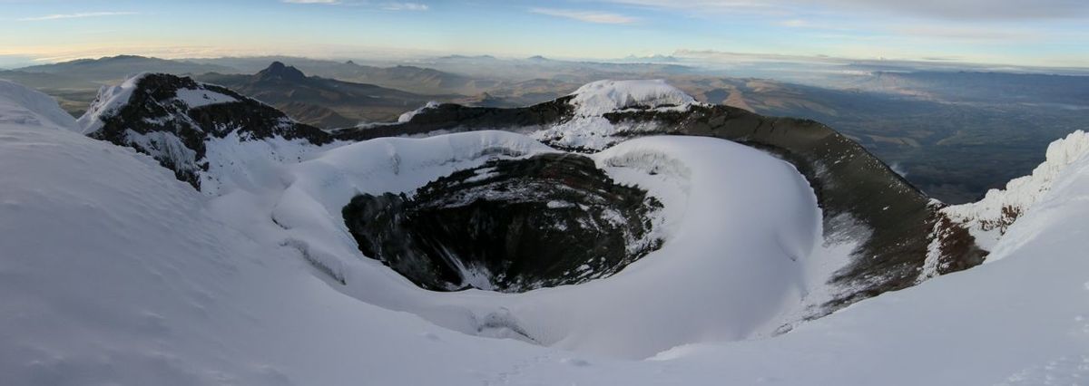
Cotopaxi’s summit is one of the most spectacular, looking down into the double rim crater and, on clear days, it is possible to see the neighbouring volcanoes of Antisana, Cayambe, Ilinizas, Chimborazo, El Altar and the active Tunguragua. The descent is done following back the same way, taking between 3-4 hours. Once back at the huts and after the whole group reunites, a short hike down (20 minutes) to the parking place and then a 3 - 4 hour drive to the town of Baños 

Ascent: 1050 m / Descent: 1315 m / Highest Altitude: 5897 m / Distance to the summit: 2.47 Km & Distance from summit to parking place: 3.22 Km / Activity duration: 10-12 h

The town of Baños, as it is locally known, lies in the Tunguragua province just at the foothills of the active Tunguragua Volcano. Baños is called the “Gateway to the Amazon'' as it’s the last andean town before reaching the Amazon basin. Due to its privileged location, this town offers plenty of activities, the best known are the hot-springs (baños).  Baños also has some great scenery with the famous waterfalls that lie a few kilometers down the valley. The best known are “El Pailon del Diablo” (Devil’s pot) and “El manto de la Novia” (the Bride’s veil), which can be visited by taking a local taxi. Also by taking the “Tarabita” (Cable-car) to cross over the Pastaza River it is possible to hike through the orchards and gardens of the local peasants.Or you can just kick back and relax at the lower altitude and enjoy the warm temperature and beautiful scenery.

After a day of leisure and a relaxing morning in the town of Baños, the group will pack and drive for 3 hours towards Chimborazo National Park. On the way, there will be a couple of short stops and time to buy the last snacks before leaving “civilization”. Chimborazo volcano is an impressive mountain that stands out from the “Volcanoes Avenue”. The indigenous farmland that surrounds the mountains are all traditionally worked and very colourful during the harvest season. While driving up to the main entrance, it is possible to see some very dramatic landscapes where old eruptions have shaped the geography of the place. After crossing the park borders, the landscape turns very arid, like a desert, where it is possible to see one of the rare South American camelids: Vicuñas. These animals are difficult to see because they live in quiet inaccessible areas. They have mastered the art of surviving in these difficult conditions. The ones living in this park are not originally from the area, but were introduced many years ago and over time became permanent residents.

The road goes all the way to the door of the lower hut “Refugio Hermanos Carrel” at 4800m. You will complete a 1 hour acclimatization hike by following the valley up to the Whymper hut at 5000m and then back down to the Carrel hut. The rest of the afternoon and evening will be to prepare for the climb and have an early dinner. Your guide will do a briefing and help with all your gear and equipment.

Ascent: 200 m / Descent: 200 m / Highest Altitude: 5000 m / Activity duration: 1.5 h

Chimborazo is the highest mountain in Ecuador and also the highest in the world measured from the center of the earth, due to its location on the tropical belt. The mountain has five major summits all linked by a ridge called the “Arista del Sol” (Sun’s ridge), which is probably the reason for its Quichua name, which translates to “Ice braid”.

The main summit is called Whymper and stands at (6268m), named after the British mountaineer Edward Whymper who was the first person to reach the summit in 1880 along with the Swiss Carrel brothers.

Climbing Chimborazo by its normal Southwest route is a challenging affair, it is a long 1468m ascent and descent and the terrain is complex, as it changes from an easy moraine trail to ice, snow and rocky sections, with some easy scrambling at some specific spots. Even though it is not a technical climb, it is physically demanding. The climb starts between 10pm to 1am, according to the team's fitness, acclimatization level and weather conditions. your guide will decide the departure time and wake up the clients up, 1 hour before, to have some breakfast and get ready for the climb. The first part of the route is no longer the normal route, but a variant known as the “Marco Cruz route”, named after the legendary Ecuadorian mountaineer who first ascended it. This variant joins the normal route after the “El Castillo” rock pillar, making the ascent much safer and more scenic. After a short while walking on the slightly exposed section hiking around the “El Castillo” rock before you come to a flat area where the variant route joins the normal route. 

The glacier rises on a wide ridge that goes up to an approximate altitude of 5850m. From this point, a gentle traverse elevates westwards reaching 6000m and then a relatively straightforward climb to the first summit, called Veintimilla at 6230m. You will then descend a few meters to cross a col and then back up to the main summit, Whymper at 6268m. This will be a truly memorable ascent and the sense of satisfaction of reaching the top of a 6000m volcano and the highest mountain in Ecuador will no doubt bring a tear to your eye. The descent is done by the same route back to the Carrel hut and, after packing, there will be a transfer ready to take the group on the 4 hour drive to Quito

Ascent: 1468 m / Descent: 1468 m / Highest Altitude: 6268 m / Activity duration: 10-12 h

This day is to allow for extra time to reach the summit and account for any weather delays in the unusual event they occur. We will endeavour to keep to the main schedule so this day will likely be spent relaxing and celebrating in Quito.

Time to say goodbye to Quito and the amazing volcanoes on the epic Summits of fire of Ecuador.

Dates & Prices

July 12 2025 - July 24 2025

£3,295pp

Or

£206 / 15 Months

8 Available Spaces

More Info

6000m Peak Essential Kit List


We've put together this equipment list for our trekking peak trips like Mera Peak, Island Peak and others. Although this list is quite detailed there might be some bits you might also want to bring that form part of your expedition or trekking kit.

While you can rent certain items in country, the quality and availability of items CANNOT be guaranteed, we therefore recommended you bring the following items yourself to avoid any issues in country...

  • High quality 4 season down sleeping bag, we recommend a rating for -20°.
  • Expedition down jacket for summit days (approx 800 fill specification)
  • Set of C1 trekking crampons compatible with normal hiking boots, these may be needed for approach and descent (not for summitting)
  • Bring your own winter B2 or B3 high altitude mountaineering boots (for Spring), or B3 boots (for Autumn).


Your Bags


Day Pack – This is your rucksack that you will use each day, we recommend a 25ltr to 35ltr, some
very popular brands are Osprey, Lowe Alpine, Berghaus.


Duffel Bag – This is the bag that will be carried by your porter and will contain the bulk of your
trekking gear, we recommend an 80ltr to 120ltr duffle bag. Popular brands are North Face, Mountain
Equipment, Osprey, Rab. For our trips in Nepal, we give you a free EverTrek 80L Duffel bag on arrival
in Kathmandu.


Dry bags and zip lock bags – These are good to keep clean and dirty kit separated and for
waterproofing your cameras and other electricals.


Sleeping Equipment


Sleeping bag – High quality 4 season down sleeping bag, we recommend a rating -20’c. to -25’c. We
do provide free rental of a down sleeping bag on arrival In Kathmandu if you don’t have your own.
For the rentals we do also recommend you bring a silk sleeping bag liner.

Note - If you're someone that feels the cold more than most it also might be worth looking at a 5 season sleeping bag for 6000m peaks or more as it can get windy and significant wind chill which you can still feel in your tents. 


Sleeping mat – Inflatable sleeping mat with a pump and ideally a repair kit for any leaks. We
recommend Thermarest mats as they are light, compact and help retain your body heat while
camping at high altitudes.


Outer Insulation Layers


Down Jacket – A High-quality heavy down jacket, this is essential to keep warm in your tent and
especially on summit day. We recommend the Rab Neutrino Pro, Mountain Equipment Lightline or
something similar in specification. We provide free rental of a trekking down jacket on arrival in
Nepal but for 6000m peak climbing we would recommend you bring a larger jacket or one of the above especially if you feel the cold more than most.


Base Layers – We Recommend you bring a mix of thermal base layers and cooler base layers as the
temps on 6000m peaks can vary massively. We recommend Merino Wool base layers.


Mid Layers - Fleece mid-layer or a lightweight down gilet.


Outer Layers – A small packable soft shell wind stopper jacket.


Rain Gear


Waterproof jacket – A light waterproof jacket, Gore-Tex or similar with a hood and good ventilation.


Waterproof over trousers – Roomy enough to wear over your normal trekking trousers, again Gore-
Tex is recommended.


Lower Body


Trekking Trousers – lightweight trekking trousers and insulated winter trekking trousers.


Trekking shorts – Lightweight, you can even use convertible trekking trousers.


Thermals – Merino Wool leggings.


Underwear and socks – Merino Wool for both, min of 6 pairs each.


Face and Head


Sun hat – Baseball cap or bucket hat


Beanie – Warm beanie hat that can covers the ears


Buff / Neck warmers – We recommended you bring a lightweight buff and a warm insulated one.
Gloves


Lightweight gloves – liner gloves and a pair of lightweight gloves for trekking and keeping warm in
camp.


Mountaineering gloves – These should be high quality big and warm gloves designed to keep your
hands from getting frostbite in the coldest climates, especially at high altitude when there is a lack of
oxygen. Recommended you buy top of the range gloves or mitts.


Handwarmers – These are great to keep your hands warm on summit night or on cold nights in the
tent, can also be put into your boots.


Footwear


Trekking boots – Hiking boots suitable for rough trails. There are heaps of options like the Meindl Bhutan boots but check out this article for more in depth options.  


Trainers / shoes – Light weight for walking around camp


Sandals – For walking to the toilet and crossing streams etc


Mountaineering Boots


For 6000m peaks such as Island Peak, Mera Peak.


A high quality pair of B2/B3 boots – Some boots we would recommend are: Scarpa Manta Tech
GTX, La Sportiva Karakorum HC GORE-TEX, Scarpa Mont Blanc Pro GORE-TEX, La Sportiva Nepal Cube
GORE-TEX.


For Peaks Aconcagua


Double mountaineering boots – You need double-layered mountaineering boots that are suitable to
climb to 7000m above sea level. Some examples: LA SPORTIVA - G2 SM, Scarpa Men's Phantom
Tech.


Mountaineering Equipment


Crampons – 12-point crampons that fit the boots, Grivel G12 are a recommended pair.


Mountaineering Harness: (These can be provided by our team in-country)


Helmet – Mountaineering helmet (These can be provided from our team in country)

Ice Axe – A trekking ice axe a popular one amongst the Yeti’s is the Black Diamond Raven Ice Axe
(These can be provided from our team in country)


Trekking Poles – Telescopic trekking poles, essential for keeping your stable on the rough terrain, uneven
sections and for reducing the stress on your joints, especially on long descents.


Head Torch – Battery powered and bring spare batteries.


Mountaineering Sunglasses – Category 4 sunglasses, Julbo are considered the best available
mountaineering glasses.


Personal hygiene and health


Sunscreen - Factor 50 sunscreen, also recommended you get a protective lip balm


Wet Wipes / Soap – essential for keeping good hygiene, put the used items in a dry bag and dispose
of correctly once off the mountain.


Towel – Small and packable.


Medications – Headaches require Ibuprofen and paracetamol, First Aid kit (your guide will also have
a fully equipped kit), Rehydration Powder: Dioralyte, Diarrhoea Treatment kit, Diamox For altitude.


Is the Summits of Fire trek on your bucket list?

Enter your email address to download our FREE Summits of Fire guide.